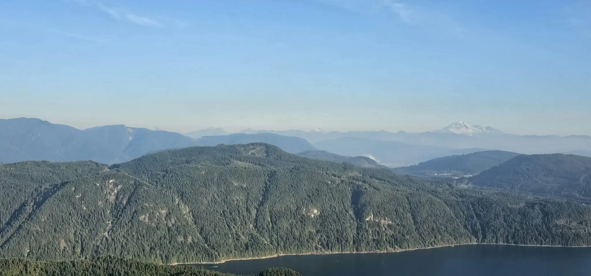
The 79 Grind hike in Mission, BC earns its name. On September 18, 2026, we followed this steep forest trail to a viewpoint overlooking the Stave Lake area, with Mount Baker on the distant horizon. Our recorded outing covered 6.08 kilometres with approximately 593 metres of cumulative ascent. We had planned a bigger mountain that week, but an injured calf, unfinished business, and two late starts brought us here instead.
79 Grind Trail — Our Trip at a Glance
Hike date: Friday, September 18, 2026
Location: Mission / Stave West, BC
Recorded distance: 6.08 km return
Cumulative ascent: Approximately 593 m
Highest GPS elevation: 693 m
Net rise from recording start: 535 m
Elapsed recording time: 2 hr 38 min 45 sec
Recording window: 4:35–7:14 p.m. PDT
Route type: Out and back
Our difficulty assessment: Strenuous
Access: Florence Lake Forest Service Road
Viewpoint break: About 10 minutes
These figures describe our recorded outing, including pauses. Cumulative ascent adds all uphill elevation changes; it differs from the net rise to the highest point. GPS altitude and ascent can vary with recording error and smoothing. The highest GPS elevation is not a surveyed summit height. Our time reflects an injured calf and is not a suggested pace.
An Injured Calf and a Change of Mountain Plans
The plan had been to do a bigger mountain this week. On the Saturday before, however, I injured my calf during a training trail run. I continued working out through the week, minus the running, but it changed what I could expect from a hike. Both the climb and the descent were substantially slower than they would normally have been.
My fitness has also been down for the last year and a half. With consistent effort, things are gradually getting back into place and shape, but that does not happen all at once. This outing came with that background: some progress, some frustration, and a calf that was making its presence felt.
That explains our pace on the day. It should not be taken as a recommendation to hike through an injury.
September 17: Two Hundred Metres, Then Back to the Car
We first intended to hike the 79 Grind on Thursday, September 17. By the time we were there, it was around 5 p.m. Starting then would have left very little margin.
My concern was not only coming down the trail late. We still had to drive back down the forest service road, with its potholes, after the hike. Finishing the walking portion does not mean the outing is over.
We checked roughly the first 200 metres of trail and then abandoned the attempt. I did not record that short reconnaissance. The GPX on this page is entirely from the following day.
September 18: Only Half an Hour Earlier
The next day unexpectedly filled up with business affairs. After dealing with what we could and leaving some matters unfinished, we finally got away. Despite returning with the intention of starting earlier, we reached the trailhead only about half an hour ahead of the previous evening.
The recording began at 4:35 p.m. The window was still small, but this time we started up the trail.
Steep Forest, Two Road Crossings, and an Enjoyable Climb
I had seen the 79 Grind described as strenuous. It really is. A relatively short distance does not tell the whole story when that distance keeps climbing.
We crossed the forest service road twice as the trail worked its way uphill through the trees. Each time we entered the next section of forest, it seemed to get a little steeper. Even so, the terrain felt manageable, and I enjoyed the trail itself. For a fit hiker comfortable with sustained uphill work, this is an appealing climb.
The difficulty for me was moving on the injured calf. I could not simply settle into my usual pace and forget about it. The trail was asking for steady work, and my leg was setting the terms.
This is the sort of place I could see myself returning to for fitness once the calf is ready. There is enough climbing to make the outing count, with a viewpoint that gives you a reason to stop at the top.
79 Grind GPX Map and Mountain Locations
The map combines our complete September 18 GPS track with labelled geographic locations for Mount Baker, Mount Robie Reid, and Mount Judge Howay. Select Hike Route to inspect the ascent and descent, or Mountain Overview to see the surrounding peaks.
Loading the route and mountain locations…
Mountain pins show geographic locations, not additional hiking destinations or verified lines of sight. Mount Baker is identifiable in our wider photograph. Robie Reid and Judge Howay are probable identifications in the closer skyline photograph. Cheam is not marked because its visibility in these images has not been confirmed.
79 Grind Elevation Profile
Recorded altitude plotted against distance. Our GPX contains approximately 593 m of cumulative ascent and a highest elevation reading of 693 m. The previous day’s unrecorded exploration is not included.
Mountain Views from the 79 Grind Lookout
The views are what make this hike more than a workout. The forest gives way to a wide outlook across the Stave Lake area and layers of ridges, with Mount Baker visible beyond them. After the climb, the sudden sense of space is a reward of its own.
The lookout is associated with Rockwell Knob, also known as Rolley Peak. The hiking destination is the viewpoint below the actual summit. An independent 79 Grind trip report also describes the Stave Lake and Mount Baker views from this lookout.
| Mountain | Direction from the viewpoint | Photograph identification |
|---|---|---|
| Mount Baker | Southeast | Identifiable as the snow-covered mountain on the right of the wider photograph. |
| Mount Robie Reid | Almost due north | Probably the broad, pale rock massif near the centre of the closer photograph. |
| Mount Judge Howay | Almost due north, slightly east of the bearing to Robie Reid | Probably the twin-peaked mountain farther right in the closer photograph. |
The geographic arrangement supports the Robie Reid and Judge Howay pairing. From the recorded upper viewpoint area, their calculated bearings are approximately 5° and 9° east of north, respectively. Judge Howay therefore sits to Robie Reid’s right when looking in that direction. This supports the interpretation without making the photograph identification conclusive.
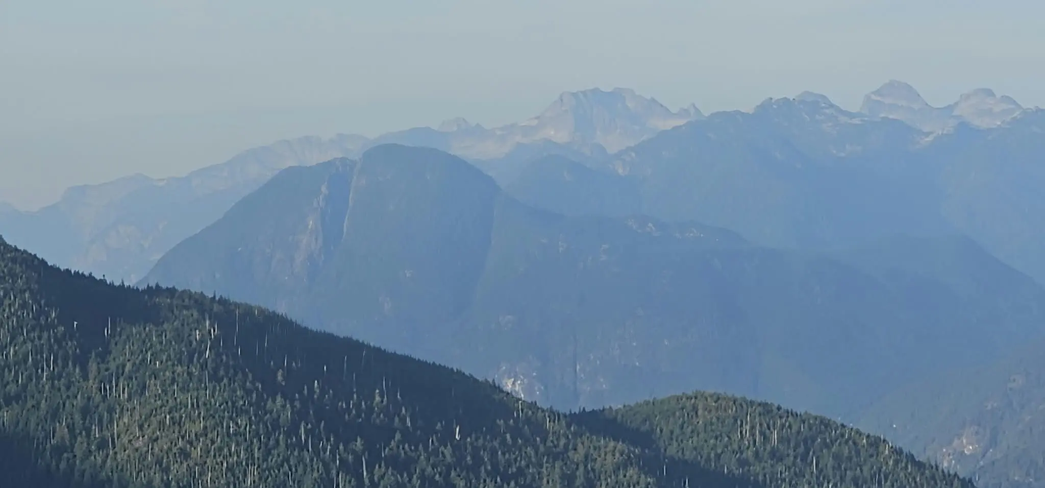
I also wondered whether Cheam was visible farther along the skyline. I have left it out of the labelled map rather than present that possibility as a confirmed sighting from our photographs.
A Short Break at the Top, Then Back into the Forest
My recollection was about an hour and fifteen minutes for the climb. The GPX reaches the upper elevation band after roughly an hour and seventeen minutes, consistent with that estimate. We spent about ten minutes at the top, took a few pictures, and then turned back.
With the evening moving along, we kept the descent purposeful, although the calf still slowed me down. We wanted to get through the forest before the remaining light disappeared. The recording ended at 7:14 p.m.; the complete recorded outing was 2 hours, 38 minutes, and 45 seconds.
That distinction matters if you are planning this hike. An hour and a quarter was my rough recollection of the ascent, not the time required for the whole trip. We also still had to drive back down the access road.
Video from the 79 Grind Viewpoint
Our video from the viewpoint. If the player does not load, watch the 79 Grind video on Dailymotion .
Trailhead Access and Why the Drive Matters
The trailhead is accessed from Florence Lake Forest Service Road. The published trail account places it roughly 6.7 km along the road from the Stave Falls powerhouse. Our recording begins near 49.281314, −122.365105; that is the start of our GPS track, not a surveyed parking location.
We encountered potholes on the access road. That was a real part of our decision to abandon the first evening’s attempt. Road conditions can change, so a previous trip report should not be treated as a guarantee that the drive will suit every vehicle.
For a return visit, I would give this hike an earlier start and leave time to enjoy the viewpoint. Plan for the forest descent and the drive out, not just the uphill time. A headlamp belongs in the pack even when the intention is to finish in daylight.
Is the 79 Grind Suitable for a Family Hike?
I think it can be a worthwhile family outing for a family already comfortable with steep hiking . There is a clear reward at the viewpoint, and the climb is enjoyable if everyone has the fitness for it.
I would not describe it as an easy family stroll. Our track gained nearly 600 metres cumulatively, and the descent still requires attention. Choose the outing around the least experienced person in the group and allow considerably more daylight than we gave ourselves.
Would I Hike the 79 Grind Again?
Definitely. This place is described as a hidden gem, and after seeing the trail and the view, I understand why. It has a satisfying climb, forest that is enjoyable to move through, and an open outlook that makes the effort feel well spent.
Once my calf is ready, I can see it becoming a useful fitness outing. Next time, I would like enough time to sit at the viewpoint without immediately calculating how much daylight remains.
A bigger mountain had been the plan. The 79 Grind still gave us a proper climb and a view worth coming back for.
79 Grind Hiking Questions
How long is the 79 Grind hike?
Our recorded out-and-back route was 6.08 km. Other recordings and route variations can differ. Use the full map above to see exactly what our distance includes.
How much elevation do you gain?
Our GPX records approximately 593 m of cumulative ascent and a highest elevation of 693 m. The net rise from the first recorded point to the highest point was approximately 535 m.
How long did the hike take?
Our recording lasted 2 hr 38 min 45 sec, including pauses. We hiked with an injured calf and a late start; our time is a trip observation, not a recommended schedule.
Can you see Mount Baker from the 79 Grind?
Yes, in clear conditions. Mount Baker is visible on the right of our wide viewpoint photograph, beyond the intervening forested ridges.
Which other mountains are shown on the map?
Mount Robie Reid and Mount Judge Howay are marked at their geographic locations north of the viewpoint. They are probable identifications in our closer skyline photograph. The markers do not certify an unobstructed line of sight.
Is the 79 Grind strenuous?
That description fits our experience. The short route contains sustained steep climbing. It is better suited to hikers comfortable with that effort than to someone expecting a gentle walk.
More Hiking Trip Reports
For another Mission outing, read our Bear Mountain hike and route report . For a bigger mountain day, see our Jim Kelly Peak and Coquihalla Mountain attempt .
Route and mountain references
Trip observations, photographs, video, and GPS data are from our September 18, 2026 outing. Additional trail context: 79 Grind to Rockwell Knob . Geographic coordinate references: Mount Robie Reid , Mount Judge Howay , and Mount Baker . Bearings and distances shown in map popups are calculated from the recorded upper viewpoint area. They are straight-line measurements, not hiking distances.